PRINCE EDWARD ISLAND REAL
ESTATE
PEI VOLUME 11 - September 28, 2005

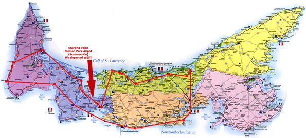
This set of Aerial photos were taken with a Nikon D70s 6+ Mega-pixel digital SLR with a Nikon 18-70mm zoom. The pictures were taken at 11:00am-2:30pm. This was one of my longest flights ever, covering most of the island, and photographing at least 38 locations including the majority of Summerside. We left Summerside Airport and travelled across to Black Point, Grand River, Birch Hill, Bideford, Alberton, Campbellton, Roseville, Cape Wolfe, North Enmore, Wellington, Fernwood, Cape Traverse, Augustine Cove, 9 Mile Creek, Cumberland, Grand Tracadie, Pleasant Grove, Brackley Shores, North Granville, French River, Seaview, Summerside, and many more in between.
Picture Sets: A | B | C | D | Home
Click on the big picture to make it BIGGER!