PRINCE EDWARD ISLAND REAL
ESTATE
PEI VOLUME 13 - July 20, 2006
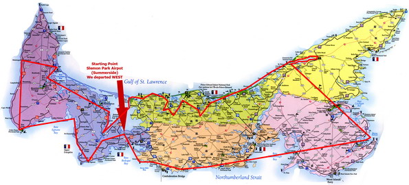
A record setting flight, almost 45 locations and 2000 photos covering almost the entire island. Complete aerial survey of St. Peters Bay (Greenwich Shore), the north shore from Greenwich to Dalvay.

This set of Aerial photos were taken with a Nikon D70s digital SLR with a Nikon 17-200mm (anti-vibration "VR") lens. The pictures were taken at 12:30pm-5:30pm. We left Summerside Airport and visited the following destinations; Summerside, Fernwood, Chelton, Augustine Cove, Hampton, Murray Islands, Georgetown, Greenwich, Rustico, New Glascow, Hope River, North Granville, New London, Springbrook, French River, Cousin's Shore, Darnley, Malpeque, Grand River, Birch Hill, Mill River, Alberton, Ebbsfleet, West Point, Dunblane, Victoria West, Baie-Egmont, Egmont Bay, Wellington, and back to the airport. This also includes a complete aerial survey of St. Peters to Dalvay.
Picture Sets: A | B | C | D | E | F | G | H | Home
Click on the big picture to make it BIGGER!